User Tools
Sidebar
Table of Contents
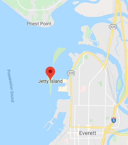
Jetty Island (Everett, WA)
Jim Schulz Nice Spring Day Downwinding
Intro
Wikipedia: “Jetty Island is a man-made island and park in the U.S. state of Washington, located 30 miles north of Seattle in the Puget Sound, just off the Everett, Washington waterfront. The island is two miles long and half a mile wide, approximately 1,800 acres.” Approx. 60 miles south of Bellingham, WA.
- Wider Area Descriptions
-
- North of Jetty Island Bellingham, etc.
-
- …
James Schulz:
“Jetty Island typically has mid/late afternoon wind in the summer almost every day during the months of April, May, June, July, and August. The simplest way to explain the wind pattern is: the Strait of Juan de Fuca is just west of Jetty, Whidbey, and Hat Islands and, almost every afternoon, winds get channeled through the Strait and spread out on the east side of the Puget Sound, Jetty (and the Seattle metro area) getting northwest winds. Those winds coming from the Juan de Fuca Strait are a product of several factors, but the two most important are daytime heating of the land surrounding the Strait and the fact that there is almost always higher pressure over the open ocean and lower pressure over inland Washington. Now air likes to flow from high to low pressure, so if there is higher pressure over the open Pacific than over Washington, the air filling the Strait will flow from west to east…right towards Jetty.
It is typically blow dryer air which means the wind is not very gusty so wave size and quality is usually better than what you think it would be for high teen to low twenty wind speeds. Look for an air temperature differential of 10 degrees or more from Port Angeles/Pt Townsend to Everett. I usually look for an incoming tide to be above 5 feet which helps the wave size and minimizes the amount of walking in the mud flat at lower tides. There’s a trail across the island that is about 200 yards long that I take which is much quicker than paddling around and therefore leaves more time and energy for surfing. Sometimes there can be some time waiting for the wind to arrive. The iKitesurf app has a wind graph that shows the predicted wind which is usually accurate in the summer months.
The water in the summer get fairly warm because the mud flats along Jetty Island and in and around Port Gardener, Port Susan heat up the sand at low tide and then heat up the water as the tide floods in, and since Port Susan is a bay the water doesn’t get flushed out so stays warmer and the Snohomish river is at low flows in the Summer.
In the late fall thru mid-spring when the Snohomish river is at high flows and during ebb tides combined with a NW, W or SW wind there are standing waves at the north end of Jetty Island between the Island and Priest Point.

The water in the summer get fairly warm because the mud flats along Jetty Island and in and around Port Gardener, Port Susan heat up the sand at low tide and then heat up the water as the tide floods in, and since Port Susan is a bay the water doesn’t get flush out so stays warmer and the Snohomish river is at low flows in the Summer.
In the late fall thru mid-spring when the Snohomish river is at high flows and during ebb tides combined with a NW, W or SW wind there are standing waves at the north end of Jetty Island between the Island and Priest Point.”
Summer Outing at Jetty - typical except maybe more boat wakes than usual
Parking and Portage to West Side of Island (Old Recommended Launch)
(but if you want to paddle in deeper south of island water, this is still the place to launch - just no need to cross the island - see photo below)
Paddle across the channel to Jetty Island from the 10th Street boat ramp
- They have new bathrooms at Jetty Landing (Ferry Launch), Free Parking for the first two hours, $2.00 for an additional 2 hours, pay at the Kiosk
- As you approach Jetty Island shore, look just south of the large diameter HDPE pipe log boom for the trail across the Island
- Just down the street from the Jetty landing they are finishing up construction on a Woods Coffee (James Schulz recommendation) - next to a West Marine supply store.
Photos of Portage across the Island (click to enlarge)

.

New Launch/Route Fall 2023
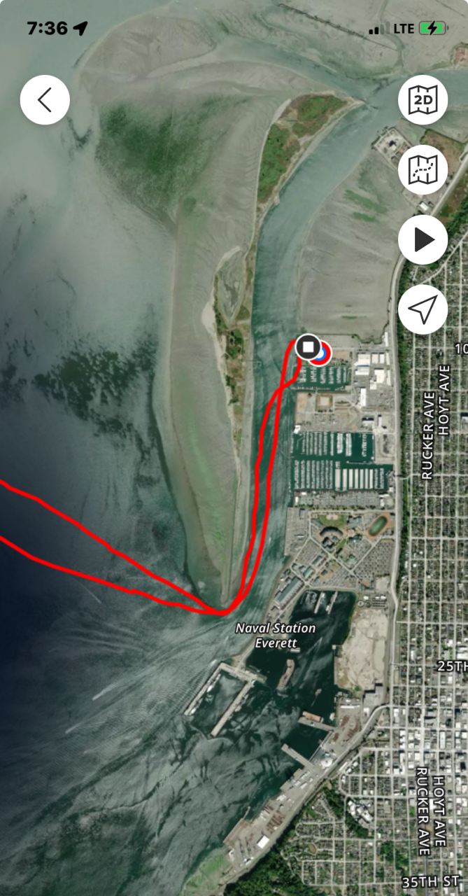
Jim Shulz: There’s a new warehouse (ONTRAC 200 W Marine View Dr) at the north end of Jetty Island where the Snohomish River splits west and south. It eliminates having to paddle the 1.25 or 1 mile into the ebbing river from the 10th Street Boat-ramp to the north end of the Island and then again back. Now we just have to set our boats in the water and have the ebbing river whisk us quickly upwind and we get a longer surfing section going into the ebbing tide. It doesn’t take much wind to make surf-able waves usually 12 mph will do it. Just start an hour or so after high tide.

More Recent top of island launch (when not at lower tides)
Deeper Channel Between Hat Island and Jetty Island
(Hat Island is about 2.5 miles directly west of Jetty Island, with Whidbey Island another 1+ miles to the west of Hat Island)
If you want to paddle in the deeper south part of the channel to avoid worry about low tide then the 10th Street launch is still the way to go. If the tide isn't low then you can walk back after laps straight across Jetty Island on the path described above. If the wind & waves tend to aim you southward during your laps, the south end of the island is narrow and an easy walk to get back into the channel to paddle back to 10th Street.
Launch for deeper south water of Possession Sound (red path is paddling around south end of Jetty Is.)
Downwind/Paddles
Jetty Island sets up well for laps to the west of island (except at lower tide), but it is possible to do a point to point paddle
- ….
Low Tide
Be aware that there are significant offshore shallows around the Island at low tide - as you can see from the green areas in the nautical chart below. Jetty Island low tides.

Conditions
- Season: Jim Shulz summary for the Snohomish Delta tide and seasonal wind “… usually the second week in May thru September is thermal season. Usually some days 6 weeks before that and then some after that. About every three weeks the ebbing river works for 4 or 5 days and the rest of the time it works better against the flooding tide but can still be good with an ebb tide. Wind is usually 13 to 22 knots. Make sure the tide is above 4.5 feet when doing the river. I used to do laps from the middle of the island (Jetty) but now prefer the south end along the deep channel. The tide can be any depth when doing the south end since the channel west of the delta is 350ish feet deep”
- …
Video
- Jim Schulz Youtube Channel - multiple Jetty Island downwinders
- North side laps Potlatch Beach to Priest Point video
