User Tools
Sidebar
lake_superior
Table of Contents
Lake Superior
.
Intro
Lake Superior is a place of extremes. Its volume would cover all of North and South America in a foot of water (10% of the world's fresh surface water). Underwater visibility is 100 feet in places. Its storms are legendary and waves of over 30 feet have been recorded. The Edmund Fitzgerald was a 700 foot long “unsinkable” iron ore freighter that broke in two and sank in a November 1975 gale. According to Gordon Lightfoot’s famous song “the lake it is said, never gives up her dead”. This is actually true as the water at the bottom is too cold for bacteria to produce the gasses that would usually bloat a corpse and cause it to float. Superior has shoreline on USA states: Minnesota, Wisconsin, Michigan, and a Canadian Province: Ontario.
Safety
Safety is a constant concern on Lake Superior. Be prepared for water temps in the 40s F (4-10 degrees Celsius)(cold water safety). In the summer an onshore breeze can push 65° F (18° C) surface water up to the shore and make swimming pleasant, but the next day if the wind changes the water will be 42° F (5.5° C) again. In the winter water temps get close to freezing. Always check your conditions
On stormy days fog and rain can destroy visibility, and GPS navigation may be needed to get in safely. There is Coast Guard support on the lake and on at least one occasion they have rescued a surfskier. DNR trip planning advice somewhat slanted toward sea kayaks but much of the advice is applicable for surfski trips.
- …
Downwind/Paddles
Lake Superior can be oceanic. There is often swell that might not line up with the wind direction. The complexity of the waves resembles the ocean not a lake. A typical 20 mph wind running down the north shore will produce 4-6 foot waves. As wind approaches 30 mph 8-10 foot and larger waves predominate. A strong NE storm can produce 10-15 foot swell waves that are extremely fast and hard to catch. There are days, such as those with near gale force winds, that are simply too dangerous to paddle.
Common Launch Spots Click on maps to enlarge
Larger Area

Zoomed view of Superior West End

…
North Shore Lake Superior (Minnesota, Ontario)
North Shore Minnesota
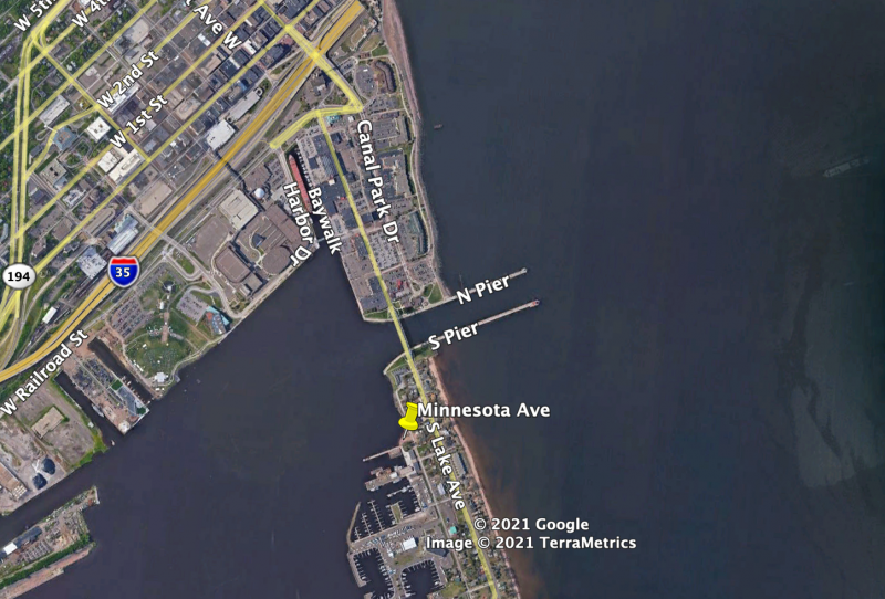
Tim Traynor: “The most spectacular routes finish in Duluth, surfing through the shipping canal and under the iconic lift bridge into the inner harbor. This requires a cautious approach as the entrance to the canal is between two long jetties and it is easy to miss the opening. Point to point downwinding on the north shore requires a NE or SW wind. Between Two Harbors and Duluth the coastline is rocky with some cliffs that get pounded by swell, and there are only a few safe launch points. Stoney Point is between Two Harbors and McQuade Harbor - 9.5 miles from Two Harbors and 6 miles from McQuade.”
Zach Handler: “Today waves are supposed to be 13’ on that run with 30mph winds all day…. I do it (this run) just a couple times a year as the 3.5 hr drive makes for a long day. When conditions are good enough to make it worth the drive it is usually fog and rain, and as soon as the waves kick up the water is 42 degrees. And there are only a few safe spots to land in the 16 mile run (Ed.: there are only a few good landings on the whole stretch between Two Harbors and the Duluth Lift Bridge); otherwise its all cliffs and boulders. When I am out there on big cold days I feel so isolated that I might as well be on the back side of the moon. It is really fun run but kind of sketch. When I finally get through the canal under the lift bridge at the end it kind of feels like I cheated death. I bet Tim (Traynor) does not get that feeling any more.”
Tim Traynor: (describing a gale warning Knife River to McQuade 2022 downwinder (video)) “The first limitation on the North Shore of Lake Superior is the limited launch and landing sites. Rocks and break walls are not forgiving. Add to this the fact that the the head of the Lake at Duluth gets highly confused and haystacky, especially entering and within the ship canal. The second consideration is of course conditions in open water, but at least you won’t be crashed on rocks or walls out there. By far the best place of launching and landing is Two Harbors but there are limited launch and landing sites up or down shore from there. I elected not to go into Duluth yesterday as I knew it would be getting very large. One of my main concerns there is getting dumped with people watching that may not understand and call a rescue, this has happened to me before elsewhere up the shore. So the bottom line is being able to get in and out reasonably. Launching at Knife River was still manageable but McQuade was starting to get sketchy when we finished. Yesterday was surprisingly messy, possibly due to a more northerly local wind and more easterly up the Lake? We had large waves coming from 2 directions which caused all sorts of havoc.”
Launches North to South
- Twin Points small cove with small beach, adjacent to Iona Beach and Iona Beach Scientific and Natural Area which has a boat ramp.
- Twin Points - McQuade Small Craft Harbor 32 miles reverse downwinder (South to North)
- Two Harbors
- Two Harbors - McQuade Small Craft Harbor 15.5 miles
- Recognizing McQuade Take-out - Tim Traynor: “…McQuade can be very hard to see until you’re only a couple kilometers away. However, there are landmarks along the way such as the old Nokomis restaurant, French River, and the new, easy to spot retaining wall about a kilometer up the shore from McQuade. Also, after passing Stoney we can see a notch in the ridge in the distance beyond McQ that lines up fairly well. Of course on low visibility days there is always GPS ”
- Reverse Run 2/25/2024 somewhat challenging with SSW onshore wind & waves
- Two Harbors - Stoney Point 9.5 miles video 4/2/2020
- Knife River
- Knife River - McQuade Small Craft Harbor 8.5 miles video 4/30/2022
- Knife River - Lester 13 miles video 5/6/2024
- Knife River - Knife Island laps video don't have someone to help with a shuttle? As long as the wind isn't blowing too hard and/or too much off shore, you can always do laps…
- Stoney Point popular for surfers (see surf below)
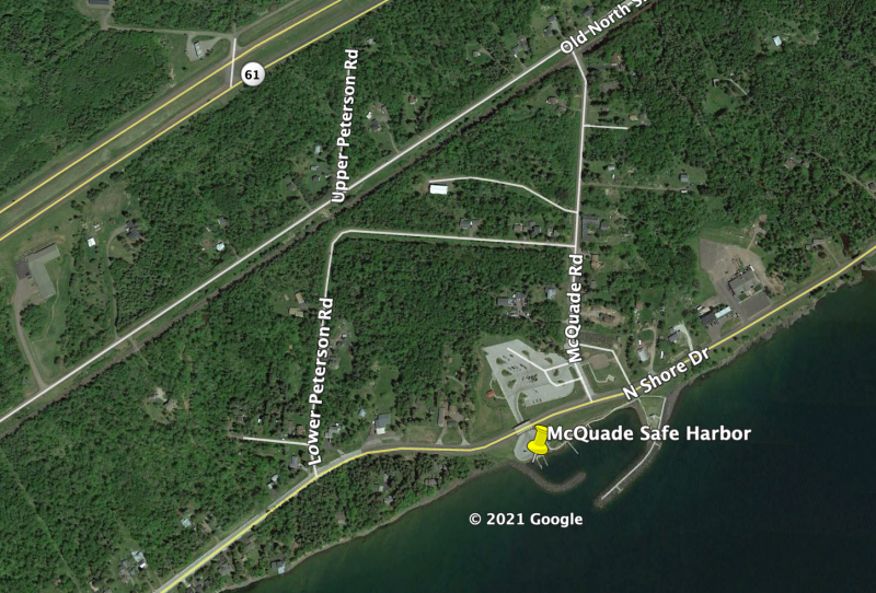
- McQuade Small Craft Harbor there is a road that goes under Congdon Blvd. to the boat ramps here. Just a few parking spots at the launch, but there is a restroom and larger parking area up this road 100 yds from Congdon Blvd.
- McQuade Small Craft Harbor - Duluth Aerial Lift Bridge 11 miles
- Duluth Aerial Lift Bridge Takeout - stay out of canal until free of ship traffic video
- …

Ship Coming Out Past Duluth Bridge
Northshore Launch google map screenshots - click to enlarge


North Shore Ontario Canada
Downwind
- As of 2024 we do not have any downwind information for the Canadian shores of Lake Superior. Much if not most of the shoreline is remote, with little or no access by road, sparsely populated, with few or no amenities, medical or rescue services. If there are good exceptions we are waiting to hear about them. Finding spots where one can do out and back laps may be more easily achieved (where some locals also surf?) than finding point to point downwinders.
- …
Surf
- Check below in Surfing (there are surfers on Canada's north shore)
Flatwater
- Thunder Bay
- 7 Nearby Paddle Routes
- …
South Shore Lake Superior (Wisconsin, Michigan)
- Wisconsin
- Chequamegon Bay
- Washburn (the Coal Dock is next to Washburn Marina)
- Coal Dock - Friendly Valley Beach approx 7 miles (this goes around a point of land near Houghton Falls State Natural Area which makes the route going north or the reverse going south a bit of a “dog-leg”)
- Coal Dock - Bono Creek (Public Boat Launch) 2.7 miles
- Washburn - Ashland 5 miles reverse video
- Bono Creek - Ashland 3.5 miles (there's a boat ramp near the Soo Line Ore Dock and probably several other reasonable places for lake access though the boat ramp may be more protected)
- Resources
- Scott Roush (facebook)
- Port Wing Area this stretch of the south shore has limited protected launches
- Herbster Campground
- Brackett's Corner - Herbster 16 miles video from 1st part of run
- Iron River Boat Access - Herbster 12.5 miles
- Port Wing Boreal Forest Trailhead - Bark Point Boat Landing 13.5 miles (have to go around to backside of Bark Point)
- …
- Michigan Upper Peninsula (The south shore of Lake Superior is also bordered by Michigan's Upper Peninsula, but we have no information about downwinding there yet)
- Downwind ??
- …
South Shore Downwinder
.
Surf
- North Shore Lake Superior
- USA/Minnesota
- Flood Bay (just north of Two Harbors)
- Sea Kayak Surfing Video 9/14/2020
- Sea Kayak Surfing Video 10/15/2020
- Surfski Surfing Video 3/13/2023
- Lester River (parking & access close to Voyageur Hwy crossing)
- Park Point (Duluth) some variations of N wind can generate shore surf here
- Surfski video 4/8/2025 if you paddle close to the lift bridge at low water watch out for pilings just below surface as shown in video
- Surfski video close to lift bridge (facebook) 10/22/2025
- Stoney Point
- Surfski video 3/7/2020
- Surfer video 8/26/2016
- Ben Gravy Surf video 2024?
- Tim Traynor about surfski surfing at Stoney Point: “Larger waves start farther out. The shelf at Stoney extends out close to 300 meters so on the biggest days the waves will start nearly out there. … I was staying a bit to the left of the main surf area so I was in a little deeper water where the waves are slower to stand but can go critical and crash hard fairly close to shore on bigger days. I always surf left towards deeper water and try to keep the break to my right. The shallowest water I was in was probably 4-5 feet.”
- Canada/Ontario
- Conditions
- Thunder Bay
- NatriBros Surf & SUP (facebook)
- Terrace Bay
- Waasaashkaa Surf Festival (facebook)
- Resources
- InfoSuperior
- …
- South Shore Lake Superior
- Michigan Upper Peninsula
- Black River & Presque Isle River sea kayaking surf video
- Wisconsin
- …
Conditions

Example why you need to locally observe (so common in many locations with variable microclimates) in addition to looking at forecasts:
2024 Tim Traynor Downwinder (video) “The forecast was for SE winds turning S. This was correct around the area except, as it turned out, for the Lake where we typically do our runs. Looking out the window from work at midday I could see there was a light NE wind on the Lake, although not quite useable. By midafternoon it built up quite nicely so Andy and I organized an impromptu run with my son driving the shuttle. We ended up having an excellent, unexpected 18k run with a 15+ knot NE wind. The Lake Superior microclimate surprises yet again! …!”
Another Tim Traynor Comment Specific to Lake Superior Conditions: “It's best to do a downwind in the building phase of a blow as once it has been going some hours the fast, long-fetch swells become too hard to catch…rounded swell being so frustrating and the remaining wind waves seem to even be blocked from the wind in the troughs, yuk.” Note! in many places the back-end of blows passing through is considered to generally be safer because the ultimate strength of a passing/building storm is not known or predicted with perfect accuracy on the front end. If you employ Tim's advice about front-end storm downwinding on Lake Superior, maybe you will want to be extra cautious? particularly when you do not have extensive local experience under your belt yet?
- …
Videos
Lake Superior Ice
.
Resources
Tim Traynor (facebook) Tim kindly provided most of the information on this page. He has been the leading discoverer and practitioner of Lake Superior surfski downwinding as far as we know.
- Duluth, MN
- Duluth Traverse Mountain bike trail
- Northern Waters Smokehaus smoked fish
- Ursa Minor Brewing Wood-fired pizza
- Taking Care of the Great Lakes
- Lake Superior Circumnavigation PaddlingtheBlue Podcast
- Our Water 1.5 hr video about their trip and protecting the lake
- …
Lake Superior Storm Surf - Not for Beginners
This page has been accessed for: Today: 4 / Yesterday: 1 / Until now: 119
Except where otherwise noted, content on this wiki is licensed under the following license: CC Attribution-Share Alike 4.0 International
